Update, 7.25pm: After sitting above 40 degrees since 12.30pm Bendigo temperatures have dropped to 38.2 degrees.
Subscribe now for unlimited access.
$0/
(min cost $0)
or signup to continue reading
The wind direction has also changed from north-west to south-west meaning the cool change that is sweeping in from the south-west of Victoria is beginning to hit central Victoria.
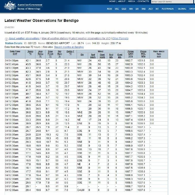
Bendigo’s peak temperature was 43.8 at 4.25pm. It is the hottest day since January 19, 2018, when the city sweltered through two days of 43 degree heat.
Update 4.15pm; A cool change is sweeping the state, but it’s still hot out there in Bendigo. At 4.20pm, the temperature reached 44.1 degrees.
Meanwhile, relief has come in other parts of Victoria – the temperature dropped from 42.7 at 1.36pm in Geelong, to 24.6 at 4pm.
It was 38 degrees at Wilsons Promontory at 2pm, and 25.3 at 4pm.
Here’s a look at Bendigo’s climbing temperature today – relief is not far off.
Update, 3.45pm:
The fire in Swanwater is now under control and Vic Emergeny has issued community information for nearby residents.
It says haystack fires are not likely to spread to grassland but do generate a lot of smoke that will be visible from roads and nearby towns.
“There is no immediate threat to the community and no action is required,” the advice reads.
Update, 3.40pm:
Temperatures are forecast to drop dramatically in central Victoria by 5.30pm.
Bureau of Meteorology forecaster Matt Michael said the cool changes looks set to arrive in Bendigo between 4pm and 5pm.
“We have had a top of 43.7 for Bendigo so far and temperatures will increase until the change goes through,” he said.
“The cool change is currently west of Mildura and extending down through Stawell, Geelong and Port Phillip Bay. In terms of direction it’s a very standard pattern (we see in storms).
“Currently it is expected just after 4pm, so it should arrive within the hour. Temperatures will drop by up to 10 degrees almost immediately and a further 10 degrees in the 20 minutes after that.
“It means in the first hour of the change the temperature will be half of what it currently is.”
Winds in the region are dry, dusty and ranging between 40km/h and 60km/h.
Mr Michael said the winds could increase as the cool change sweeps through.
“The could increase but only to 60 or 70km/h,” he said. “They will shift around to become fresh, gusty south-south-westerly winds at around 4.30pm.”
Across the region, it has reached 44.5 in Kerang, 44.3 at Charlton and 42.7 at Redesdale.
Update, 2.56pm:
Country Fire Authority crews are responding to a haystack small fire in Swanwater – located between St Arnaud and Donald.
Four tankers from Cope Cope, Jeffcott, Donald and Gooroc have made the situation safe but the fire is not yet under control.
Update, 2.50pm:
Neil Morgan of the Bendigo-based Wildlife Rescue Emergency Service said today had been “surprisingly pretty good” in terms of the number of calls he received regarding heat-stressed animals.
Mr Morgan said his only concern was there were fewer people out and about, so any ill animals might not be seen.
He said he was keeping an eye on the flying foxes in Rosalind Park, which in previous years have required special attention in heatwaves.
Mr Morgan advised people to put out containers of water for wildlife on hot days such as today.
Any unusual behaviour from an animal, such as possums on the ground rather than in the trees, was a sign something was wrong, he said.
Anyone who finds an animal they suspect is in heat stress or otherwise ill should call WRES on 0427 301 401.
Update, 2pm: Bendigo reached 41.7 degrees at 1.30pm today while Charlton currently sits at 43.5 degrees and Swan Hill is a shade higher at 43.9 degrees.
The increased temperature has forced some Bendigo stores to closes and regional events to be postponed.
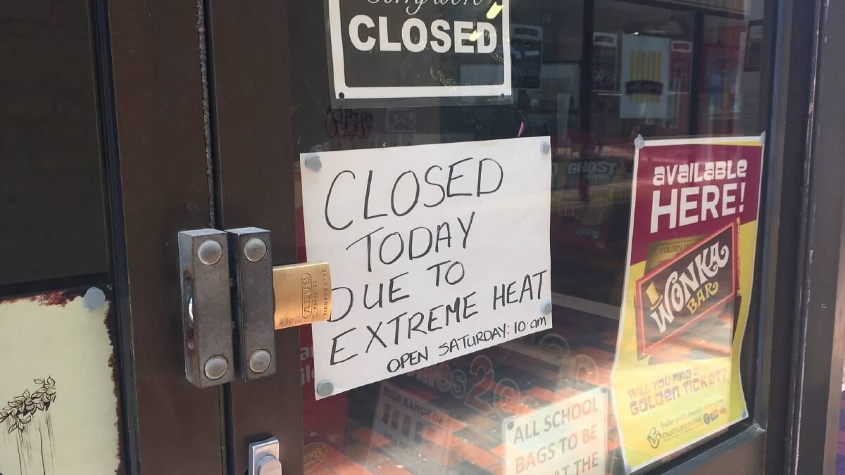
Lollies2Go in Bendigo closed due to extreme heat while the Bendigo Summer in the Parks outdoor cinema event in Redesdale has been postponed until 8pm tomorrow.
A fire weather warning remains in place for the Mallee, Wimmera, Northern Country and North Central districts.
Update, 12:50pm:
Conditions today are “not far behind” those of Black Saturday, Les Vearing, emergency incident controller at Bendigo, said.
Mr Vearing said the state had not seen the same weather conditions since Black Saturday on February 9, 2009, which left 173 people dead and lead to widespread destruction.
“Black Saturday was one of those really, really horrible days and we haven’t seen any since,” he said.
“But today is the closest we’ve seen to Black Saturday. And it’s not that far behind what Black Saturday was. Everybody remembers how destructive that was.
“Today has almost the same potential as Black Saturday”.
Mr Vearing advised that if you don’t need to be on the roads today “don’t be there”.
“You could have a car accident which then starts a bushfire. You don’t want to trapped at in a fire,” he said.
“Stay at home and put the air conditioner on.”
Update, 11.15: A cool change could hit with "quite a punch" as it reaches parts of Victoria today.
Some parts of the state could see damaging wind gusts, Bureau of Meteorology senior forecaster Tom Delamotte said, though a warning area does not extend to central Victoria.
"Even elsewhere in the state we are going to see a very squally wind change move through," he said.
"It does look like the strongest winds will only last for an hour or two following the change. We do see the winds easing off following that."

The BOM is predicting the southwesterly change to blow at about 25 to 40km/h when it hits Bendigo and Echuca.
Castlemaine and Maryborough can expect peak gusts at 50km/h
Temperatures have risen "very quickly" this morning, Mr Delamotte said.
At 11am the temperature in Bendigo was 36.8 degrees, climbing from 28.7 at 9am.
Charlton is currently sitting at 38.7 degrees at Redesdale at 35.4.
A cool change has already reached Victoria's south-west coastal region, bringing 20 degrees to Portland.
"We expect that change to accelerate through this afternoon and into this evening, probably reaching the Melbourne area by 4pm," he said.
Update: 9.45am: Two Country Fire Authority units have extinguished a car fire in Maiden Gully, just hours into a total fire ban day.
Police are headed to the scene in Andrews Road, with the fire determined as safe by firefighters.
A spokesperson from the state emergency control centre said CFA units attended the fire before 9am today.
The CFA has issued a total fire ban for the whole of Victoria today.
It means no fire can be lit in the open air or be allowed to remain alight in the open air between 12.01am and 11.59pm.
North Central and Northern Country areas have an extreme bushfire danger rating today.
Update, Friday, 8.45am: Yes, that sudden, gusty change is still coming this afternoon but don’t expect temperatures to drop as dramatically here as they could on the coast.
Central Victoria can expect a drop of 10 degrees when the wind changes late this afternoon, breaking the 45 degree heat, Bureau of Meteorology senior forecaster Tom Delamotte said.
The BOM yesterday predicted Melbourne could see temperatures plummet from 42 degrees to into the high 20s in the hour after 3pm.
Central Victorians will have to wait a little longer for the weather to ease.
At this stage the BOM predicts Castlemaine and Maryborough could see the change between 4pm and 5pm, likely reaching Bendigo not too long afterwards. In Echuca it could be closer to 7pm.
There is the chance of dust being kicked up by wind gusts in the northwest of the state.
An extreme fire danger rating is in force for the Mallee, Wimmera, Northern Country and North Central forecast districts, with a severe fire danger forecast for the South West, Central and West and South Gippsland districts.
In Bendigo and across the state emergency services and government agencies have gathered to watch and act in case of bushfires.
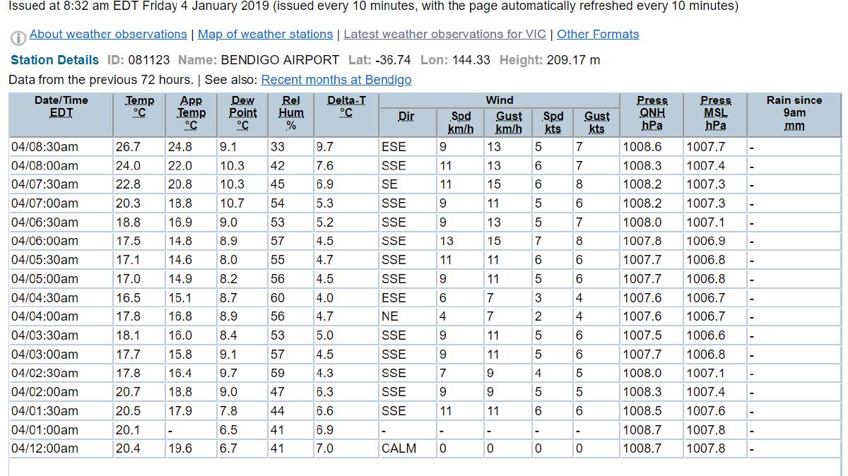
Current temperature: 26.7 degrees in Bendigo.
Last night’s lowest temperature: dropped down to 16 degrees at 4.30am.
The BOM’s automatic weather station is now back up and running after a breakdown compounded by staff shortages over the Christmas holidays.
If you’re heading outdoors for a swim, or to find some shade, take care of heatstroke and dehydration.
Here are some tips from the health authorities.
Drink plenty of water Always take a bottle with you.
Hot cars kill Never leave kids, adults or pets in cars. The temperature inside a parked car can double within minutes.
Keep cool Seek out air-conditioned buildings, use a fan, take cool showers and dress in light, loose clothing made from natural fabrics.
Plan ahead Schedule activities in the coolest part of the day and avoid exercising in the heat. If you must go out, wear a hat and sunscreen and take a bottle of water with you.
Help others Look after those most at risk in the heat - your friends and family or your neighbour living alone, the elderly, the young, people with a medical condition and don't forget your pets.
Water Safety Inland waterways, including rivers, creeks, lakes and dams are great for water recreation, but it is important to remember they have many hidden dangers, such as submerged objects, debris and strong currents. Follow these four safety tips: 1. Wear a life jacket. 2. Avoid alcohol around water. 3. Never swim alone. 4. Learn how to save a life.
UPDATE, 6.30pm: Bendigo’s top temperature for Friday is now forecast at 45 degrees.
The Bureau of Meteorology has issued a Fire Weather Warning with very hot, dry and gusty winds forecast.
It says Extreme Fire Danger is forecast for the Mallee, Wimmera, Northern Country and North Central.
The CFA has advised people to action their Bushfire Survival Plan and monitor the fire and weather situation through your local radio station, www.emergency.vic.gov.au and www.bom.gov.au
In an emergency contact Triple Zero.
UPDATE 3pm: The heat has already caused V/Line to cancel a train service on the Bendigo line.
Thursday’s 6.25pm service from Southern Cross to Swan Hill will be replaced by coaches because of the extreme heat.
V/Line’s modified extreme heat timetable applies to the Bendigo line on Thursday and will continue to run on Friday, when temperatures are forecast to grow even hotter.
To view these timetables, visit the V/Line website.
EARLIER: Victorian organisations are warning against bushfires and heat-related illness as a combination of hot wind and high temperatures develop Victoria.
Bureau of Meteorology senior meteorologist Dean Stewart said parts of northern Victoria are already seeing hot conditions.
“Temperatures are already in the high 30s and touching 40 degrees along the Murray River,” he said.
“Overall the conditions are not too bad today. The big change is tomorrow with northerly winds develop over the state.”
Mr Stewart said hot air will get pushed across inland Victoria with many towns in northern Victoria facing temperatures in the mid 40s while southern locations will reach the low 40s.
Bendigo is forecast to reach 44 on Friday while Echuca (46), Swan Hill (46), Castlemaine (43), Maryborough (44) and Kyneton (41) all expecting to see the mercury climb above 40 degrees.
The cool change has Bendigo’s top forecast for 27 on Saturday.
“The reason we are getting these northerly winds is that they are ahead of an approaching cold front,”
“It is directing warm air from inland Australia across Victoria. So we are getting temperatures into the mid-40s, and possibly record temperatures in some places.
“It’s not often we get temperatures like 45 or 46.”
The Department of Health and Human Services has issued heat health alerts for the Mallee, Wimmera, Northern Country, North Central and North East districts.
It is possible the high temperatures will affect some people’s health with older people, young children and people with a medical condition the most likely to be affected.
Dehydration, lack of airflow, sun exposure and hot and crowded conditions can cause heat stress or heat related illness.
Symptoms include deterioration in existing medical conditions, heat rash, heat cramps, dizziness and fainting, heat exhaustion and heatstroke.
Heatstroke occurs when the body’s temperature goes above 40.5 degrees and requires urgent medical attention. Many organs in the body suffer damage from heatstroke and the body temperature must be reduced quickly.
Mr Stewart said the combination of Friday’s hot winds and high temperatures means people should be aware of potential bushfires.
“That combination leads to the fire danger being set at severe or extreme. The CFA has already issued a total fire ban for Victoria.”
Mr Stewart said Melbourne is preparing for its hottest day in three years with a forecast of 42.
”It will only be short lived with the cold front reaching Melbourne around 4pm and the temperature dropping to the mi-20s that evening,” he said.
Have you signed up to the Bendigo Advertiser's daily newsletter and breaking news emails? You can register below and make sure you are up to date with everything that's happening in central Victoria.


